


Le Coulet

ARVIEU
User
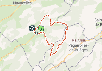


4h09
Difficulty : Medium

FREE GPS app for hiking
 SityTrail
IGN / Geographical institutes
SityTrail Plus
The world is yours!
About
Trail Walking of 14.3 km to be discovered at Occitania, Hérault, Saint-Maurice-Navacelles. This trail is proposed by ARVIEU.
Description
Au départ du Coulet sur la commune de St Maurice de Navacelles, une rando qui mène après une petite ascension sur la crête au dessus de Pégairolles de Buèges, avec vue sur le sud jusqu'à la mer, et au nord sur la massif du Mont Aigoual.
Positioning
Comments