
Tour de l'Hubac Faron - Toulon

affinetataille
User GUIDE
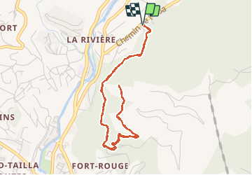

Length
5.8 km

Max alt
270 m

Uphill gradient
245 m
Km-Effort
9.1 km

Min alt
100 m

Downhill gradient
244 m
Boucle
Yes
Creation date :
2020-08-20 06:14:47.421
Updated on :
2020-08-23 21:02:40.926
2h02
Difficulty : Easy

FREE GPS app for hiking
 SityTrail
IGN / Geographical institutes
SityTrail Plus
The world is yours!
About
Trail Walking of 5.8 km to be discovered at Provence-Alpes-Côte d'Azur, Var, Toulon. This trail is proposed by affinetataille.
Photos


Positioning
Country:
France
Region :
Provence-Alpes-Côte d'Azur
Department/Province :
Var
Municipality :
Toulon
Location:
Unknown
Start:(Dec)
Start:(UTM)
737577 ; 4782243 (31T) N.
Comments