


montée langlade

antoine.demaison
User
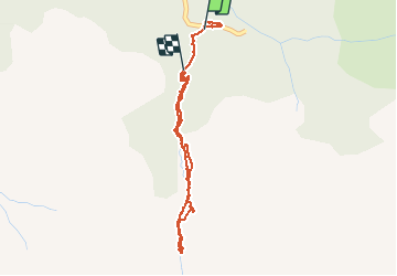

Length
4 km

Max alt
1567 m

Uphill gradient
328 m
Km-Effort
7.9 km

Min alt
1216 m

Downhill gradient
194 m
Boucle
No
Creation date :
2020-08-19 08:49:10.877
Updated on :
2020-08-20 09:17:06.773
3h03
Difficulty : Easy

FREE GPS app for hiking
 SityTrail
IGN / Geographical institutes
SityTrail Plus
The world is yours!
About
Trail Walking of 4 km to be discovered at Occitania, Ariège, Couflens. This trail is proposed by antoine.demaison.
Positioning
Country:
France
Region :
Occitania
Department/Province :
Ariège
Municipality :
Couflens
Location:
Unknown
Start:(Dec)
Start:(UTM)
352693 ; 4733645 (31T) N.
Comments