


200820-baeréthal

maureengeorges
User
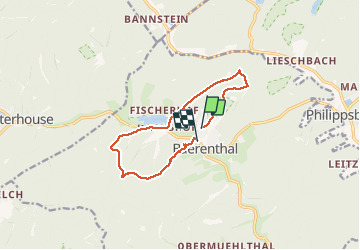

Length
10.2 km

Max alt
393 m

Uphill gradient
352 m
Km-Effort
14.9 km

Min alt
206 m

Downhill gradient
360 m
Boucle
No
Creation date :
2020-08-20 06:56:00.0
Updated on :
2020-08-20 09:49:57.966
2h52
Difficulty : Unknown

FREE GPS app for hiking
 SityTrail
IGN / Geographical institutes
SityTrail Plus
The world is yours!
About
Trail Walking of 10.2 km to be discovered at Grand Est, Moselle, Baerenthal. This trail is proposed by maureengeorges.
Positioning
Country:
France
Region :
Grand Est
Department/Province :
Moselle
Municipality :
Baerenthal
Location:
Unknown
Start:(Dec)
Start:(UTM)
391482 ; 5426274 (32U) N.
Comments