


Foret de Leoncel

jphugon
User
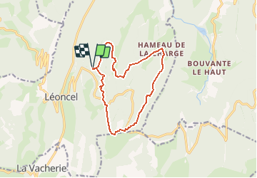

Length
12.8 km

Max alt
1336 m

Uphill gradient
532 m
Km-Effort
19.9 km

Min alt
950 m

Downhill gradient
532 m
Boucle
Yes
Creation date :
2020-08-21 07:05:26.987
Updated on :
2020-08-21 07:06:48.053
--
Difficulty : Medium

FREE GPS app for hiking
 SityTrail
IGN / Geographical institutes
SityTrail Plus
The world is yours!
About
Trail On foot of 12.8 km to be discovered at Auvergne-Rhône-Alpes, Drôme, Léoncel. This trail is proposed by jphugon.
Positioning
Country:
France
Region :
Auvergne-Rhône-Alpes
Department/Province :
Drôme
Municipality :
Léoncel
Location:
Unknown
Start:(Dec)
Start:(UTM)
674250 ; 4976623 (31T) N.
Comments