


Uzel

A-Lise
User

Length
10 km

Max alt
424 m

Uphill gradient
265 m
Km-Effort
13.5 km

Min alt
233 m

Downhill gradient
260 m
Boucle
Yes
Creation date :
2020-08-21 07:13:04.0
Updated on :
2020-08-21 10:21:29.523
2h48
Difficulty : Very easy

FREE GPS app for hiking
 SityTrail
IGN / Geographical institutes
SityTrail Plus
The world is yours!
About
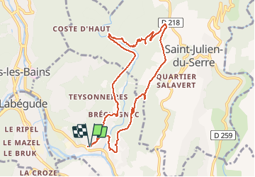
Trail Walking of 10 km to be discovered at Auvergne-Rhône-Alpes, Ardèche, Ucel. This trail is proposed by A-Lise .
Description
Très belle rando ombragée avec de beaux points de vue
Positioning
Country:
France
Region :
Auvergne-Rhône-Alpes
Department/Province :
Ardèche
Municipality :
Ucel
Location:
Unknown
Start:(Dec)
Start:(UTM)
609727 ; 4944153 (31T) N.
Comments