pont d'Orbeil

ppn
User
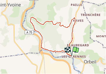

Length
8.4 km

Max alt
555 m

Uphill gradient
242 m
Km-Effort
11.7 km

Min alt
360 m

Downhill gradient
246 m
Boucle
Yes
Creation date :
2020-08-21 07:26:29.338
Updated on :
2020-08-21 15:02:05.056
2h24
Difficulty : Very easy

FREE GPS app for hiking
 SityTrail
IGN / Geographical institutes
SityTrail Plus
The world is yours!
About
Trail Walking of 8.4 km to be discovered at Auvergne-Rhône-Alpes, Puy-de-Dôme, Orbeil. This trail is proposed by ppn.
Positioning
Country:
France
Region :
Auvergne-Rhône-Alpes
Department/Province :
Puy-de-Dôme
Municipality :
Orbeil
Location:
Unknown
Start:(Dec)
Start:(UTM)
520957 ; 5045635 (31T) N.
Comments