


st aupre

GALIBER
User

Length
17.5 km

Max alt
893 m

Uphill gradient
581 m
Km-Effort
25 km

Min alt
464 m

Downhill gradient
581 m
Boucle
Yes
Creation date :
2020-08-22 07:22:00.415
Updated on :
2020-08-22 15:57:44.582
5h55
Difficulty : Very easy

FREE GPS app for hiking
 SityTrail
IGN / Geographical institutes
SityTrail Plus
The world is yours!
About
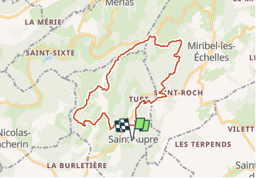
Trail Walking of 17.5 km to be discovered at Auvergne-Rhône-Alpes, Isère, Saint-Aupre. This trail is proposed by GALIBER.
Positioning
Country:
France
Region :
Auvergne-Rhône-Alpes
Department/Province :
Isère
Municipality :
Saint-Aupre
Location:
Unknown
Start:(Dec)
Start:(UTM)
708964 ; 5030622 (31T) N.
Comments