


Saint bresson... montdahin (ancien 44)

PatriceCocuaud
User
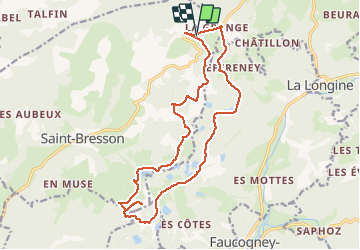

Length
17.9 km

Max alt
666 m

Uphill gradient
371 m
Km-Effort
23 km

Min alt
498 m

Downhill gradient
370 m
Boucle
Yes
Creation date :
2020-08-23 07:34:59.261
Updated on :
2020-08-23 12:17:06.392
2h52
Difficulty : Easy

FREE GPS app for hiking
 SityTrail
IGN / Geographical institutes
SityTrail Plus
The world is yours!
About
Trail Mountain bike of 17.9 km to be discovered at Bourgogne-Franche-Comté, Haute-Saône, Saint-Bresson. This trail is proposed by PatriceCocuaud.
Description
2 points merdiques et retour route
Positioning
Country:
France
Region :
Bourgogne-Franche-Comté
Department/Province :
Haute-Saône
Municipality :
Saint-Bresson
Location:
Unknown
Start:(Dec)
Start:(UTM)
316537 ; 5307371 (32T) N.
Comments