


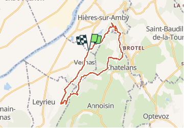
vernas

edwige84
User

Length
15.1 km

Max alt
420 m

Uphill gradient
487 m
Km-Effort
22 km

Min alt
232 m

Downhill gradient
484 m
Boucle
Yes
Creation date :
2020-08-23 07:35:17.01
Updated on :
2020-08-23 12:51:19.255
4h04
Difficulty : Easy

FREE GPS app for hiking
 SityTrail
IGN / Geographical institutes
SityTrail Plus
The world is yours!
About
Trail Walking of 15.1 km to be discovered at Auvergne-Rhône-Alpes, Isère, Hières-sur-Amby. This trail is proposed by edwige84.
Positioning
Country:
France
Region :
Auvergne-Rhône-Alpes
Department/Province :
Isère
Municipality :
Hières-sur-Amby
Location:
Unknown
Start:(Dec)
Start:(UTM)
677579 ; 5072335 (31T) N.
Comments