


Activity

m261212
User

Length
22 km

Max alt
542 m

Uphill gradient
304 m
Km-Effort
26 km

Min alt
262 m

Downhill gradient
412 m
Boucle
No
Creation date :
2020-08-23 15:29:07.149
Updated on :
2020-08-31 12:47:02.416
1h30
Difficulty : Very easy

FREE GPS app for hiking
 SityTrail
IGN / Geographical institutes
SityTrail Plus
The world is yours!
About
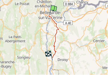
Trail Bicycle tourism of 22 km to be discovered at Auvergne-Rhône-Alpes, Ain, Valserhône. This trail is proposed by m261212.
Positioning
Country:
France
Region :
Auvergne-Rhône-Alpes
Department/Province :
Ain
Municipality :
Valserhône
Location:
Bellegarde-sur-Valserine
Start:(Dec)
Start:(UTM)
718147 ; 5109916 (31T) N.
Comments