


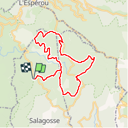
La Luzette

ARVIEU
User

Length
18.8 km

Max alt
1366 m

Uphill gradient
345 m
Km-Effort
23 km

Min alt
1213 m

Downhill gradient
341 m
Boucle
Yes
Creation date :
2014-12-10 00:00:00.0
Updated on :
2014-12-10 00:00:00.0
5h08
Difficulty : Medium

FREE GPS app for hiking
 SityTrail
IGN / Geographical institutes
SityTrail Plus
The world is yours!
About
Trail Walking of 18.8 km to be discovered at Occitania, Gard, Bréau-Mars. This trail is proposed by ARVIEU.
Description
La Luzette par le Col du Minier
Positioning
Country:
France
Region :
Occitania
Department/Province :
Gard
Municipality :
Bréau-Mars
Location:
Unknown
Start:(Dec)
Start:(UTM)
543860 ; 4878044 (31T) N.
Comments