


montherme .lyre.faire.2020.08.25

trusgnachjf
User
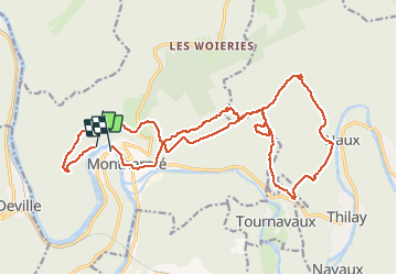

Length
24 km

Max alt
425 m

Uphill gradient
826 m
Km-Effort
35 km

Min alt
132 m

Downhill gradient
854 m
Boucle
No
Creation date :
2020-08-25 07:51:44.159
Updated on :
2020-08-25 16:22:59.617
7h03
Difficulty : Very easy

FREE GPS app for hiking
 SityTrail
IGN / Geographical institutes
SityTrail Plus
The world is yours!
About
Trail Walking of 24 km to be discovered at Grand Est, Ardennes, Monthermé. This trail is proposed by trusgnachjf.
Positioning
Country:
France
Region :
Grand Est
Department/Province :
Ardennes
Municipality :
Monthermé
Location:
Unknown
Start:(Dec)
Start:(UTM)
624259 ; 5527586 (31U) N.
Comments