


Les Lacs du Marillet et de la Moinie
Rando Vendée
La marche c'est la santée
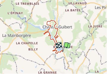

Length
12.4 km

Max alt
55 m

Uphill gradient
157 m
Km-Effort
14.5 km

Min alt
10 m

Downhill gradient
158 m
Boucle
Yes
Creation date :
2020-08-26 09:01:52.0
Updated on :
2020-08-26 14:59:41.678
3h19
Difficulty : Medium

FREE GPS app for hiking
 SityTrail
IGN / Geographical institutes
SityTrail Plus
The world is yours!
About
Trail Walking of 12.4 km to be discovered at Pays de la Loire, Vendée, Château-Guibert. This trail is proposed by Rando Vendée.
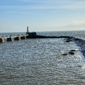
Photos


Positioning
Country:
France
Region :
Pays de la Loire
Department/Province :
Vendée
Municipality :
Château-Guibert
Location:
Unknown
Start:(Dec)
Start:(UTM)
635637 ; 5157676 (30T) N.
Comments