


Ron Obron

pb07
User
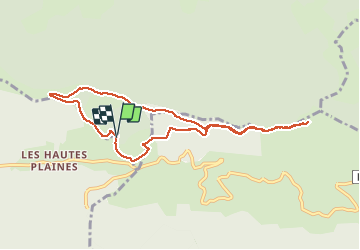

Length
8.8 km

Max alt
1526 m

Uphill gradient
297 m
Km-Effort
12.8 km

Min alt
1316 m

Downhill gradient
304 m
Boucle
Yes
Creation date :
2020-08-27 13:57:39.734
Updated on :
2020-08-27 18:05:12.596
3h49
Difficulty : Very easy

FREE GPS app for hiking
 SityTrail
IGN / Geographical institutes
SityTrail Plus
The world is yours!
About
Trail Walking of 8.8 km to be discovered at Auvergne-Rhône-Alpes, Ardèche, Mayres. This trail is proposed by pb07.
Positioning
Country:
France
Region :
Auvergne-Rhône-Alpes
Department/Province :
Ardèche
Municipality :
Mayres
Location:
Unknown
Start:(Dec)
Start:(UTM)
586778 ; 4943452 (31T) N.
Comments