


Ménil sur Belvitte 8 2020

JeanPierreNancy
User
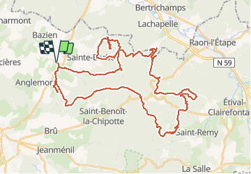

Length
53 km

Max alt
488 m

Uphill gradient
946 m
Km-Effort
66 km

Min alt
275 m

Downhill gradient
946 m
Boucle
Yes
Creation date :
2020-08-29 07:56:42.309
Updated on :
2020-09-01 07:53:20.338
4h12
Difficulty : Medium

FREE GPS app for hiking
 SityTrail
IGN / Geographical institutes
SityTrail Plus
The world is yours!
About
Trail Mountain bike of 53 km to be discovered at Grand Est, Vosges, Ménil-sur-Belvitte. This trail is proposed by JeanPierreNancy.
Photos

Positioning
Country:
France
Region :
Grand Est
Department/Province :
Vosges
Municipality :
Ménil-sur-Belvitte
Location:
Unknown
Start:(Dec)
Start:(UTM)
328984 ; 5362582 (32U) N.
Comments