


MONT MACARON DEPUIS VIEUX NICE

topolino
User
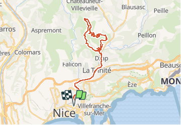

Length
36 km

Max alt
779 m

Uphill gradient
930 m
Km-Effort
48 km

Min alt
17 m

Downhill gradient
930 m
Boucle
Yes
Creation date :
2020-08-30 08:08:32.223
Updated on :
2020-08-30 08:10:23.363
3h06
Difficulty : Difficult

FREE GPS app for hiking
 SityTrail
IGN / Geographical institutes
SityTrail Plus
The world is yours!
About
Trail Mountain bike of 36 km to be discovered at Provence-Alpes-Côte d'Azur, Maritime Alps, Nice. This trail is proposed by topolino.
Positioning
Country:
France
Region :
Provence-Alpes-Côte d'Azur
Department/Province :
Maritime Alps
Municipality :
Nice
Location:
Unknown
Start:(Dec)
Start:(UTM)
361664 ; 4840831 (32T) N.
Comments