


Activity

m261212
User

Length
3.2 km

Max alt
482 m

Uphill gradient
27 m
Km-Effort
3.6 km

Min alt
467 m

Downhill gradient
18 m
Boucle
No
Creation date :
2020-08-30 14:04:40.526
Updated on :
2020-08-30 16:09:29.386
--
Difficulty : Very easy

FREE GPS app for hiking
 SityTrail
IGN / Geographical institutes
SityTrail Plus
The world is yours!
About
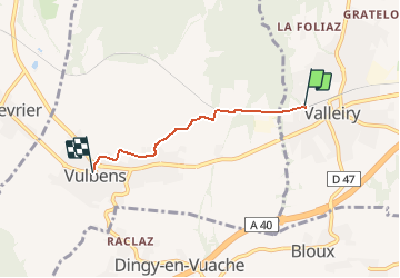
Trail Bicycle tourism of 3.2 km to be discovered at Auvergne-Rhône-Alpes, Upper Savoy, Valleiry. This trail is proposed by m261212.
Positioning
Country:
France
Region :
Auvergne-Rhône-Alpes
Department/Province :
Upper Savoy
Municipality :
Valleiry
Location:
Unknown
Start:(Dec)
Start:(UTM)
729037 ; 5110397 (31T) N.
Comments