


BM-rando du 30.08.2020

bene_dictus77
User

Length
20 km

Max alt
130 m

Uphill gradient
258 m
Km-Effort
24 km

Min alt
38 m

Downhill gradient
279 m
Boucle
No
Creation date :
2020-08-30 09:48:48.202
Updated on :
2020-08-30 15:45:38.259
5h28
Difficulty : Very easy

FREE GPS app for hiking
 SityTrail
IGN / Geographical institutes
SityTrail Plus
The world is yours!
About
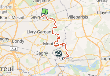
Trail Walking of 20 km to be discovered at Ile-de-France, Seine-Saint-Denis, Sevran. This trail is proposed by bene_dictus77.
Description
De Sevran à Chelles via la Poudrerie, la Forêt de Bondy, Montfermeil et la Montagne de Chelles.
Positioning
Country:
France
Region :
Ile-de-France
Department/Province :
Seine-Saint-Denis
Municipality :
Sevran
Location:
Unknown
Start:(Dec)
Start:(UTM)
465901 ; 5420513 (31U) N.
Comments