


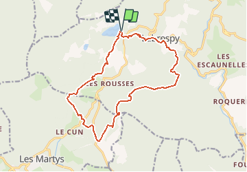
bcle Est des montagnes

Dupleix
User

Length
17.1 km

Max alt
968 m

Uphill gradient
553 m
Km-Effort
25 km

Min alt
575 m

Downhill gradient
553 m
Boucle
Yes
Creation date :
2020-08-31 13:18:50.225
Updated on :
2020-08-31 13:23:57.915
6h00
Difficulty : Medium

FREE GPS app for hiking
 SityTrail
IGN / Geographical institutes
SityTrail Plus
The world is yours!
About
Trail On foot of 17.1 km to be discovered at Occitania, Tarn, Mazamet. This trail is proposed by Dupleix.
Description
les montagnès,labrespy,la paladille,crete du sambres,le cun,lss rousses,les montagnes
Positioning
Country:
France
Region :
Occitania
Department/Province :
Tarn
Municipality :
Mazamet
Location:
Unknown
Start:(Dec)
Start:(UTM)
447117 ; 4812372 (31T) N.
Comments