


depart marnoz

gerardmicheline
User
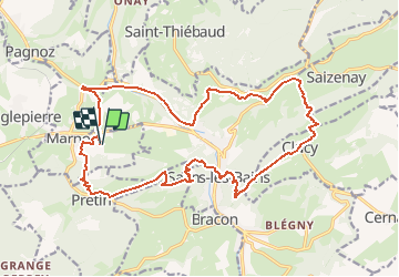

Length
21 km

Max alt
652 m

Uphill gradient
965 m
Km-Effort
34 km

Min alt
300 m

Downhill gradient
972 m
Boucle
Yes
Creation date :
2020-08-31 16:18:26.342
Updated on :
2020-08-31 16:31:42.048
6h58
Difficulty : Very difficult

FREE GPS app for hiking
 SityTrail
IGN / Geographical institutes
SityTrail Plus
The world is yours!
About
Trail Walking of 21 km to be discovered at Bourgogne-Franche-Comté, Jura, Marnoz. This trail is proposed by gerardmicheline.
Description
fort belin ;fort saint andré; chemin des gabelous
Positioning
Country:
France
Region :
Bourgogne-Franche-Comté
Department/Province :
Jura
Municipality :
Marnoz
Location:
Unknown
Start:(Dec)
Start:(UTM)
716300 ; 5203229 (31T) N.
Comments