


Perrigny - voie PLM - Chatillon

daniellebou
User
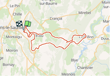

Length
36 km

Max alt
584 m

Uphill gradient
817 m
Km-Effort
47 km

Min alt
360 m

Downhill gradient
816 m
Boucle
Yes
Creation date :
2020-08-31 22:18:22.416
Updated on :
2020-09-29 17:24:14.58
--
Difficulty : Very easy

FREE GPS app for hiking
 SityTrail
IGN / Geographical institutes
SityTrail Plus
The world is yours!
About
Trail Hybrid bike of 36 km to be discovered at Bourgogne-Franche-Comté, Jura, Perrigny. This trail is proposed by daniellebou.
Description
Moins de dénivelé que Sitytrail indique car tunnel (540 m dénivelé).
Photos


25 photos in total. Please click on a photo to see them all in the gallery.
Positioning
Country:
France
Region :
Bourgogne-Franche-Comté
Department/Province :
Jura
Municipality :
Perrigny
Location:
Unknown
Start:(Dec)
Start:(UTM)
698039 ; 5171599 (31T) N.
Comments