


plagefortbloc

maxEA65
User
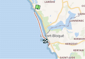

Length
2.2 km

Max alt
7 m

Uphill gradient
5 m
Km-Effort
2.3 km

Min alt
0 m

Downhill gradient
1 m
Boucle
No
Creation date :
2020-09-01 10:21:01.953
Updated on :
2020-09-01 11:09:54.414
48m
Difficulty : Very easy

FREE GPS app for hiking
 SityTrail
IGN / Geographical institutes
SityTrail Plus
The world is yours!
About
Trail Walking of 2.2 km to be discovered at Brittany, Morbihan, Guidel. This trail is proposed by maxEA65.
Positioning
Country:
France
Region :
Brittany
Department/Province :
Morbihan
Municipality :
Guidel
Location:
Unknown
Start:(Dec)
Start:(UTM)
461776 ; 5288474 (30T) N.
Comments