


Rohrbach groupe

Specialized77
User GUIDE
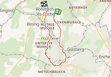

Length
11.1 km

Max alt
341 m

Uphill gradient
155 m
Km-Effort
13.2 km

Min alt
255 m

Downhill gradient
166 m
Boucle
No
Creation date :
2020-09-01 12:04:30.475
Updated on :
2020-09-01 15:17:37.994
2h58
Difficulty : Easy

FREE GPS app for hiking
 SityTrail
IGN / Geographical institutes
SityTrail Plus
The world is yours!
About
Trail Walking of 11.1 km to be discovered at Grand Est, Moselle, Rohrbach-lès-Bitche. This trail is proposed by Specialized77.
Positioning
Country:
France
Region :
Grand Est
Department/Province :
Moselle
Municipality :
Rohrbach-lès-Bitche
Location:
Unknown
Start:(Dec)
Start:(UTM)
373927 ; 5433407 (32U) N.
Comments