


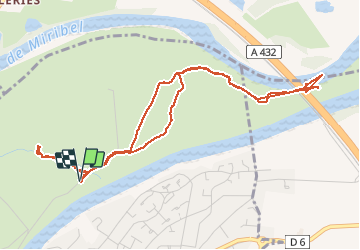
pont de Jonage 01 09 20-raccourci en partie est pour Yvonne-6.1 a 41 g0.5 d18

jtraverse
User

Length
6.1 km

Max alt
191 m

Uphill gradient
41 m
Km-Effort
6.7 km

Min alt
177 m

Downhill gradient
41 m
Boucle
Yes
Creation date :
2020-09-01 12:20:01.149
Updated on :
2020-09-02 07:38:01.704
2h22
Difficulty : Very easy

FREE GPS app for hiking
 SityTrail
IGN / Geographical institutes
SityTrail Plus
The world is yours!
About
Trail Walking of 6.1 km to be discovered at Auvergne-Rhône-Alpes, Métropole de Lyon, Jonage. This trail is proposed by jtraverse.
Positioning
Country:
France
Region :
Auvergne-Rhône-Alpes
Department/Province :
Métropole de Lyon
Municipality :
Jonage
Location:
Unknown
Start:(Dec)
Start:(UTM)
658883 ; 5074232 (31T) N.
Comments