


Marche Chazay

GOHIER
User

Length
7.3 km

Max alt
378 m

Uphill gradient
186 m
Km-Effort
9.8 km

Min alt
205 m

Downhill gradient
186 m
Boucle
Yes
Creation date :
2020-09-02 08:17:04.0
Updated on :
2020-09-02 10:02:27.162
1h45
Difficulty : Unknown

FREE GPS app for hiking
 SityTrail
IGN / Geographical institutes
SityTrail Plus
The world is yours!
About
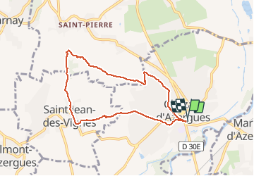
Trail Nordic walking of 7.3 km to be discovered at Auvergne-Rhône-Alpes, Rhône, Chazay-d'Azergues. This trail is proposed by GOHIER.
Description
Dans les vignes
Positioning
Country:
France
Region :
Auvergne-Rhône-Alpes
Department/Province :
Rhône
Municipality :
Chazay-d'Azergues
Location:
Unknown
Start:(Dec)
Start:(UTM)
632869 ; 5081481 (31T) N.
Comments