


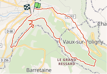
poligny belvedaire

Zindeler Vince
User

Length
6.6 km

Max alt
513 m

Uphill gradient
274 m
Km-Effort
10.3 km

Min alt
335 m

Downhill gradient
273 m
Boucle
Yes
Creation date :
2020-09-02 12:32:42.741
Updated on :
2020-09-02 14:49:11.439
2h01
Difficulty : Very easy

FREE GPS app for hiking
 SityTrail
IGN / Geographical institutes
SityTrail Plus
The world is yours!
About
Trail Walking of 6.6 km to be discovered at Bourgogne-Franche-Comté, Jura, Poligny. This trail is proposed by Zindeler Vince.
Positioning
Country:
France
Region :
Bourgogne-Franche-Comté
Department/Province :
Jura
Municipality :
Poligny
Location:
Unknown
Start:(Dec)
Start:(UTM)
706574 ; 5190067 (31T) N.
Comments