


chemin stéphane

funkady
User
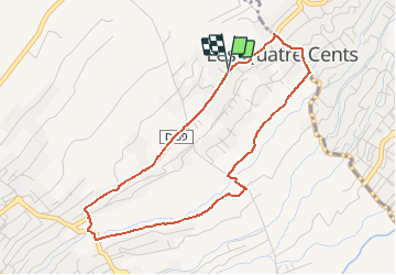

Length
5.6 km

Max alt
465 m

Uphill gradient
178 m
Km-Effort
8 km

Min alt
286 m

Downhill gradient
174 m
Boucle
Yes
Creation date :
2020-09-04 06:10:25.246
Updated on :
2020-09-04 06:11:52.199
30m
Difficulty : Very easy

FREE GPS app for hiking
 SityTrail
IGN / Geographical institutes
SityTrail Plus
The world is yours!
About
Trail Trail of 5.6 km to be discovered at Réunion, Unknown, Saint-Pierre. This trail is proposed by funkady.
Positioning
Country:
France
Region :
Réunion
Department/Province :
Unknown
Municipality :
Saint-Pierre
Location:
Unknown
Start:(Dec)
Start:(UTM)
343394 ; 7646934 (40K) S.
Comments