


forêt de Choiseul par pont noir.

dcharbonnier
User
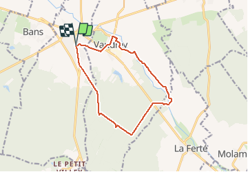

Length
12.8 km

Max alt
264 m

Uphill gradient
124 m
Km-Effort
14.5 km

Min alt
216 m

Downhill gradient
124 m
Boucle
Yes
Creation date :
2020-09-04 11:29:25.5
Updated on :
2020-09-04 14:35:21.202
3h05
Difficulty : Very easy

FREE GPS app for hiking
 SityTrail
IGN / Geographical institutes
SityTrail Plus
The world is yours!
About
Trail Walking of 12.8 km to be discovered at Bourgogne-Franche-Comté, Jura, Mont-sous-Vaudrey. This trail is proposed by dcharbonnier.
Positioning
Country:
France
Region :
Bourgogne-Franche-Comté
Department/Province :
Jura
Municipality :
Mont-sous-Vaudrey
Location:
Unknown
Start:(Dec)
Start:(UTM)
698003 ; 5205900 (31T) N.
Comments