


wattissart

Michel Zante
User

Length
13.6 km

Max alt
203 m

Uphill gradient
181 m
Km-Effort
16.1 km

Min alt
122 m

Downhill gradient
181 m
Boucle
Yes
Creation date :
2020-09-03 12:02:44.742
Updated on :
2020-09-05 07:29:03.609
2h40
Difficulty : Very easy

FREE GPS app for hiking
 SityTrail
IGN / Geographical institutes
SityTrail Plus
The world is yours!
About
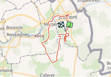
Trail Walking of 13.6 km to be discovered at Hauts-de-France, Nord, Jeumont. This trail is proposed by Michel Zante.
Positioning
Country:
France
Region :
Hauts-de-France
Department/Province :
Nord
Municipality :
Jeumont
Location:
Unknown
Start:(Dec)
Start:(UTM)
578078 ; 5571190 (31U) N.
Comments