


Le pont du Tarn

pb07
User
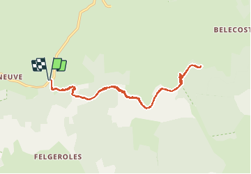

Length
9.9 km

Max alt
1340 m

Uphill gradient
116 m
Km-Effort
11.5 km

Min alt
1264 m

Downhill gradient
114 m
Boucle
Yes
Creation date :
2020-09-05 08:10:08.174
Updated on :
2020-09-06 16:52:26.209
5h25
Difficulty : Easy

FREE GPS app for hiking
 SityTrail
IGN / Geographical institutes
SityTrail Plus
The world is yours!
About
Trail Walking of 9.9 km to be discovered at Occitania, Lozère, Pont de Montvert - Sud Mont Lozère. This trail is proposed by pb07.
Positioning
Country:
France
Region :
Occitania
Department/Province :
Lozère
Municipality :
Pont de Montvert - Sud Mont Lozère
Location:
Le Pont-de-Montvert
Start:(Dec)
Start:(UTM)
562948 ; 4913623 (31T) N.
Comments