


gerardmer septembre 2020

cemoi
User
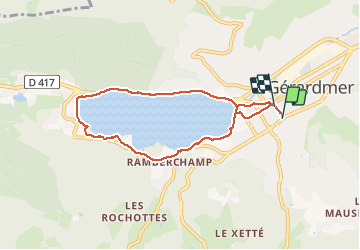

Length
6.7 km

Max alt
696 m

Uphill gradient
85 m
Km-Effort
7.9 km

Min alt
656 m

Downhill gradient
86 m
Boucle
Yes
Creation date :
2020-09-06 13:04:37.595
Updated on :
2020-09-06 14:43:54.106
1h38
Difficulty : Very easy

FREE GPS app for hiking
 SityTrail
IGN / Geographical institutes
SityTrail Plus
The world is yours!
About
Trail Walking of 6.7 km to be discovered at Grand Est, Vosges, Gérardmer. This trail is proposed by cemoi.
Positioning
Country:
France
Region :
Grand Est
Department/Province :
Vosges
Municipality :
Gérardmer
Location:
Unknown
Start:(Dec)
Start:(UTM)
341677 ; 5326208 (32U) N.
Comments