


RIF-01-09-20 du 06.09.2020

bene_dictus77
User
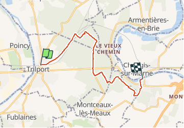

Length
10.6 km

Max alt
137 m

Uphill gradient
130 m
Km-Effort
12.3 km

Min alt
50 m

Downhill gradient
139 m
Boucle
No
Creation date :
2020-09-06 09:27:34.655
Updated on :
2020-09-06 15:16:29.108
4h12
Difficulty : Very easy

FREE GPS app for hiking
 SityTrail
IGN / Geographical institutes
SityTrail Plus
The world is yours!
About
Trail Walking of 10.6 km to be discovered at Ile-de-France, Seine-et-Marne, Trilport. This trail is proposed by bene_dictus77.
Description
de Trilport à Changis
Positioning
Country:
France
Region :
Ile-de-France
Department/Province :
Seine-et-Marne
Municipality :
Trilport
Location:
Unknown
Start:(Dec)
Start:(UTM)
496285 ; 5423052 (31U) N.
Comments