


Monts - Ruisseau de Montison - 9km 95m 2h05 - 2020 09 06

Orcal37
User GUIDE
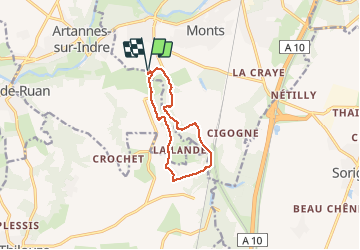

Length
9 km

Max alt
100 m

Uphill gradient
96 m
Km-Effort
10.3 km

Min alt
56 m

Downhill gradient
95 m
Boucle
Yes
Creation date :
2020-09-06 12:59:22.507
Updated on :
2020-09-06 16:39:51.134
2h05
Difficulty : Easy

FREE GPS app for hiking
 SityTrail
IGN / Geographical institutes
SityTrail Plus
The world is yours!
About
Trail Walking of 9 km to be discovered at Centre-Loire Valley, Indre-et-Loire, Monts. This trail is proposed by Orcal37.
Description
Monts - lieu-dit les Girardières Ruisseau de Montison - 9km 95m 2h05 - 2020 09 06
Photos


Positioning
Country:
France
Region :
Centre-Loire Valley
Department/Province :
Indre-et-Loire
Municipality :
Monts
Location:
Unknown
Start:(Dec)
Start:(UTM)
320160 ; 5237404 (31T) N.
Comments