


fruitiere

bouscaillou
User
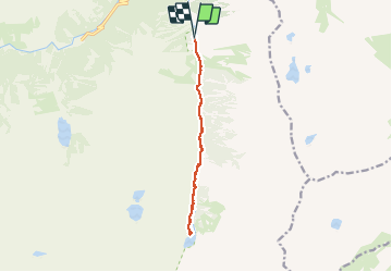

Length
12.4 km

Max alt
1814 m

Uphill gradient
455 m
Km-Effort
18.4 km

Min alt
1369 m

Downhill gradient
455 m
Boucle
Yes
Creation date :
2020-09-07 09:26:34.055
Updated on :
2020-09-07 17:57:04.973
6h58
Difficulty : Very easy

FREE GPS app for hiking
 SityTrail
IGN / Geographical institutes
SityTrail Plus
The world is yours!
About
Trail Walking of 12.4 km to be discovered at Occitania, Hautespyrenees, Cauterets. This trail is proposed by bouscaillou.
Positioning
Country:
France
Region :
Occitania
Department/Province :
Hautespyrenees
Municipality :
Cauterets
Location:
Unknown
Start:(Dec)
Start:(UTM)
737090 ; 4748605 (30T) N.
Comments