


GR 10 - 3

loic09
User

Length
250 km

Max alt
2428 m

Uphill gradient
17980 m
Km-Effort
489 km

Min alt
535 m

Downhill gradient
17556 m
Boucle
No
Creation date :
2014-12-10 00:00:00.0
Updated on :
2014-12-10 00:00:00.0
89h08
Difficulty : Medium

FREE GPS app for hiking
 SityTrail
IGN / Geographical institutes
SityTrail Plus
The world is yours!
About
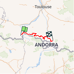
Trail Walking of 250 km to be discovered at Occitania, Haute-Garonne, Bagnères-de-Luchon. This trail is proposed by loic09.
Description
De Bagnères de Luchon à Merens les vals
Positioning
Country:
France
Region :
Occitania
Department/Province :
Haute-Garonne
Municipality :
Bagnères-de-Luchon
Location:
Unknown
Start:(Dec)
Start:(UTM)
302976 ; 4740465 (31T) N.
Comments
Guide clair et facile à suivre grâce au tracé GPS. Chemin GR10 bien balisé et parfait pour un randonneur. Beaux paysages. En 1 mot : SUPER.