


GR 10 - 4

loic09
User

Length
190 km

Max alt
2485 m

Uphill gradient
10189 m
Km-Effort
330 km

Min alt
4 m

Downhill gradient
11247 m
Boucle
No
Creation date :
2014-12-10 00:00:00.0
Updated on :
2014-12-10 00:00:00.0
70h20
Difficulty : Medium

FREE GPS app for hiking
 SityTrail
IGN / Geographical institutes
SityTrail Plus
The world is yours!
About
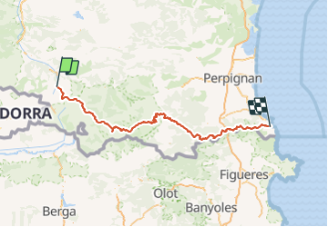
Trail Walking of 190 km to be discovered at Occitania, Ariège, Mérens-les-Vals. This trail is proposed by loic09.
Description
De Merens les vals jusqu'à Banyuls
Positioning
Country:
France
Region :
Occitania
Department/Province :
Ariège
Municipality :
Mérens-les-Vals
Location:
Unknown
Start:(Dec)
Start:(UTM)
404626 ; 4723407 (31T) N.
Comments
