


Dieulouard 8 9 2020

JeanPierreNancy
User
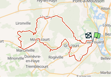

Length
49 km

Max alt
342 m

Uphill gradient
825 m
Km-Effort
60 km

Min alt
193 m

Downhill gradient
821 m
Boucle
Yes
Creation date :
2020-09-08 07:47:11.406
Updated on :
2020-09-08 12:24:12.315
3h40
Difficulty : Medium

FREE GPS app for hiking
 SityTrail
IGN / Geographical institutes
SityTrail Plus
The world is yours!
About
Trail Mountain bike of 49 km to be discovered at Grand Est, Meurthe-et-Moselle, Dieulouard. This trail is proposed by JeanPierreNancy.
Positioning
Country:
France
Region :
Grand Est
Department/Province :
Meurthe-et-Moselle
Municipality :
Dieulouard
Location:
Unknown
Start:(Dec)
Start:(UTM)
284607 ; 5413973 (32U) N.
Comments