


2020-09-08_16h10m11_St_Bonnet_Troncy_Ranchal

daniellebou
User
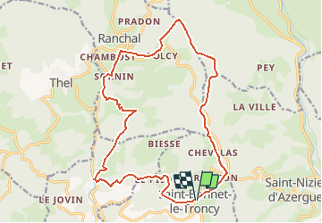

Length
19.4 km

Max alt
896 m

Uphill gradient
773 m
Km-Effort
30 km

Min alt
545 m

Downhill gradient
776 m
Boucle
Yes
Creation date :
2020-09-08 14:10:11.319
Updated on :
2020-09-27 14:45:12.395
6h09
Difficulty : Very difficult

FREE GPS app for hiking
 SityTrail
IGN / Geographical institutes
SityTrail Plus
The world is yours!
About
Trail Walking of 19.4 km to be discovered at Auvergne-Rhône-Alpes, Rhône, Saint-Bonnet-le-Troncy. This trail is proposed by daniellebou.
Positioning
Country:
France
Region :
Auvergne-Rhône-Alpes
Department/Province :
Rhône
Municipality :
Saint-Bonnet-le-Troncy
Location:
Unknown
Start:(Dec)
Start:(UTM)
610385 ; 5104467 (31T) N.
Comments