


Etg Fallavier 088 09 20

jtraverse
User
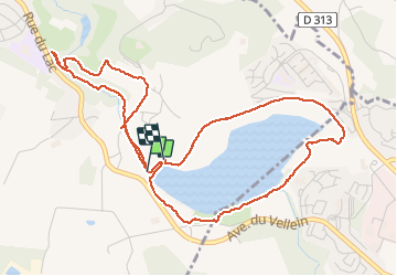

Length
6 km

Max alt
304 m

Uphill gradient
91 m
Km-Effort
7.2 km

Min alt
272 m

Downhill gradient
86 m
Boucle
Yes
Creation date :
2020-09-08 12:17:16.759
Updated on :
2020-09-08 14:35:39.613
2h17
Difficulty : Very easy

FREE GPS app for hiking
 SityTrail
IGN / Geographical institutes
SityTrail Plus
The world is yours!
About
Trail Walking of 6 km to be discovered at Auvergne-Rhône-Alpes, Isère, Saint-Quentin-Fallavier. This trail is proposed by jtraverse.
Positioning
Country:
France
Region :
Auvergne-Rhône-Alpes
Department/Province :
Isère
Municipality :
Saint-Quentin-Fallavier
Location:
Unknown
Start:(Dec)
Start:(UTM)
665529 ; 5054144 (31T) N.
Comments