


praz.torraz.christomet.granges.2020.09.08

trusgnachjf
User
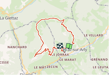

Length
21 km

Max alt
1922 m

Uphill gradient
1055 m
Km-Effort
35 km

Min alt
1050 m

Downhill gradient
1055 m
Boucle
Yes
Creation date :
2020-09-08 07:25:41.046
Updated on :
2020-09-08 18:02:04.71
9h14
Difficulty : Very easy

FREE GPS app for hiking
 SityTrail
IGN / Geographical institutes
SityTrail Plus
The world is yours!
About
Trail Walking of 21 km to be discovered at Auvergne-Rhône-Alpes, Upper Savoy, Praz-sur-Arly. This trail is proposed by trusgnachjf.
Positioning
Country:
France
Region :
Auvergne-Rhône-Alpes
Department/Province :
Upper Savoy
Municipality :
Praz-sur-Arly
Location:
Unknown
Start:(Dec)
Start:(UTM)
310403 ; 5078667 (32T) N.
Comments