Trail Walking Giffaumont-Champaubert - LAC dur DER ... la forêt, la terre et l'eau.  - Photo

LAC dur DER ... la forêt, la terre et l'eau.

© OpenStreetMap contributors
Length
Length
13.5 km
Max alt
Max alt
154 m
Uphill gradient
Uphill gradient
100 m
Km-Effort
Km-Effort  
14.9 km
Min alt
Min alt
133 m
Downhill gradient
Downhill gradient
100 m
Boucle
Boucle
Yes
Creation date :
2020-09-09 11:20:49.81
Updated on :
2020-09-17 09:07:15.784

(0 Reviews)

Walking
Walking
3h32
Difficulty : Very easy

Scan this QR Code to open this trail in the SityTrail application

FREE GPS app for hiking

Logo SityTrail SityTrail

IGN / Geographical institutes

Download SityTrail from the App Store Download SityTrail from Google Play

Logo SityTrail SityTrail World

The world is yours!

Download SityTrail from the App Store Download SityTrail from Google Play Download SityTrail on Huawei AppGallery

About

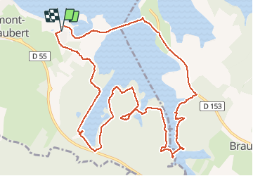
Trail Walking of 13.5 km to be discovered at Grand Est, Marne, Giffaumont-Champaubert. This trail is proposed by GerardBouche.

Description

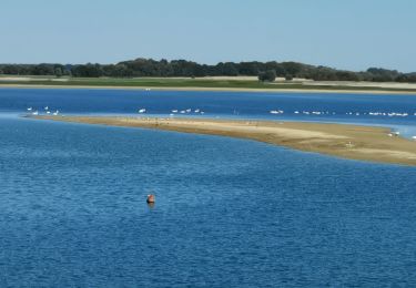
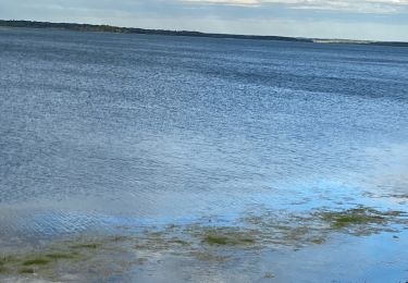
Depuis la station nautique de Giffaumont par la longue passerelle de Champaubert et un sentier longeant la D153. La suite par un très beau sentier forestier dans le Bois des Moines, l'étang "la Dame" et l'étang "Chevalier".
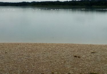
!!! Après avoir franchi la digue de l'étang Chevalier (au km 7.3) ne pas tourner à gauche, le sentier est impraticable et envahi par des ronciers !!!

Elevation profile

Photos

Positioning

Country:
France
Region :
Grand Est
Department/Province :
Marne
Municipality :
Giffaumont-Champaubert
Location:
Unknown
Start:(UTM)
630530 ; 5379351 (31U) N.

Trails nearby

Trail Mountain bike Éclaron-Braucourt-Sainte-Livière - Espace VTT FFC Lac du Der en Champagne - Circuit n°08 - La Forêt du Der - Photo
Mountain bike
tracegps

Mountain bike

Medium
(1)
Éclaron-Braucourt-Sainte-Livière, Grand Est, Haute-Marne, France
19.5 km | 22 km-effort
1h 30min
Yes
Trail Walking Giffaumont-Champaubert - Voyage autour des Etangs - Photo
Walking
tracegps

Walking

Easy
(2)
Giffaumont-Champaubert, Grand Est, Marne, France
7.2 km | 8 km-effort
1h 30min
Yes
Trail Mountain bike Éclaron-Braucourt-Sainte-Livière - Tour du lac du Der - Photo
Mountain bike
tracegps

Mountain bike

Medium
(1)
Éclaron-Braucourt-Sainte-Livière, Grand Est, Haute-Marne, France
36 km | 39 km-effort
2h 0min
Yes
Trail On foot Giffaumont-Champaubert - Circuit des Étangs d'Outines - Photo
On foot
PRO

On foot

Easy
Giffaumont-Champaubert, Grand Est, Marne, France
6.2 km | 6.7 km-effort
1h 31min
No
Trail Walking Éclaron-Braucourt-Sainte-Livière - Tour cornet du Der - Photo
Walking
ggguerin

Walking

Easy
Éclaron-Braucourt-Sainte-Livière, Grand Est, Haute-Marne, France
10.2 km | 11.6 km-effort
3h 30min
Yes
Trail Walking Giffaumont-Champaubert - LAC du DER ... balade autour des étangs.  - Photo
Walking
GerardBouche

Walking

Very easy
(1)
Giffaumont-Champaubert, Grand Est, Marne, France
8.1 km | 9 km-effort
2h 25min
Yes
Trail Road bike Éclaron-Braucourt-Sainte-Livière - 2020 08 25 lac de der - Photo
Road bike
pauldurand

Road bike

Éclaron-Braucourt-Sainte-Livière, Grand Est, Haute-Marne, France
17.9 km | 19.5 km-effort
1h 42min
No
Trail Walking Giffaumont-Champaubert - ghifaumont - Photo
Walking
ghislaine61

Walking

Very easy
Giffaumont-Champaubert, Grand Est, Marne, France
12.3 km | 13.8 km-effort
2h 48min
No
Trail Walking Giffaumont-Champaubert - Lac du Der 09-04-2014 - Photo
Walking
JD51290

Walking

Very easy
(1)
Giffaumont-Champaubert, Grand Est, Marne, France
12.7 km | 14 km-effort
2h 59min
Yes


Close
My subscriptions