


09.09.2020 - TANOUARN

babeth35
User
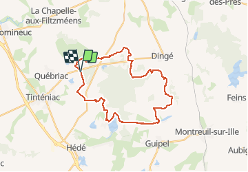

Length
30 km

Max alt
109 m

Uphill gradient
244 m
Km-Effort
33 km

Min alt
55 m

Downhill gradient
242 m
Boucle
Yes
Creation date :
2020-09-09 05:49:52.0
Updated on :
2020-09-09 15:17:55.195
7h24
Difficulty : Medium

FREE GPS app for hiking
 SityTrail
IGN / Geographical institutes
SityTrail Plus
The world is yours!
About
Trail Walking of 30 km to be discovered at Brittany, Ille-et-Vilaine, Québriac. This trail is proposed by babeth35.
Positioning
Country:
France
Region :
Brittany
Department/Province :
Ille-et-Vilaine
Municipality :
Québriac
Location:
Unknown
Start:(Dec)
Start:(UTM)
589168 ; 5355483 (30U) N.
Comments