


depart marnoz saint michel haut fait le 8-9-2020

gerardmicheline
User
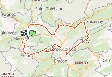

Length
21 km

Max alt
651 m

Uphill gradient
941 m
Km-Effort
34 km

Min alt
300 m

Downhill gradient
952 m
Boucle
Yes
Creation date :
2020-09-08 06:59:50.364
Updated on :
2020-09-10 06:46:44.742
5h24
Difficulty : Difficult

FREE GPS app for hiking
 SityTrail
IGN / Geographical institutes
SityTrail Plus
The world is yours!
About
Trail Walking of 21 km to be discovered at Bourgogne-Franche-Comté, Jura, Marnoz. This trail is proposed by gerardmicheline.
Positioning
Country:
France
Region :
Bourgogne-Franche-Comté
Department/Province :
Jura
Municipality :
Marnoz
Location:
Unknown
Start:(Dec)
Start:(UTM)
716253 ; 5203251 (31T) N.
Comments