


pic de charance

mayaud
User
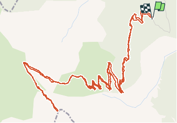

Length
12.5 km

Max alt
2304 m

Uphill gradient
854 m
Km-Effort
24 km

Min alt
1581 m

Downhill gradient
857 m
Boucle
Yes
Creation date :
2020-09-10 06:58:59.388
Updated on :
2020-09-10 12:40:59.797
5h04
Difficulty : Medium

FREE GPS app for hiking
 SityTrail
IGN / Geographical institutes
SityTrail Plus
The world is yours!
About
Trail Walking of 12.5 km to be discovered at Provence-Alpes-Côte d'Azur, Hautes-Alpes, Crots. This trail is proposed by mayaud.
Description
col de la baisse
Positioning
Country:
France
Region :
Provence-Alpes-Côte d'Azur
Department/Province :
Hautes-Alpes
Municipality :
Crots
Location:
Unknown
Start:(Dec)
Start:(UTM)
297328 ; 4929123 (32T) N.
Comments