


Cernans

cmike39
User
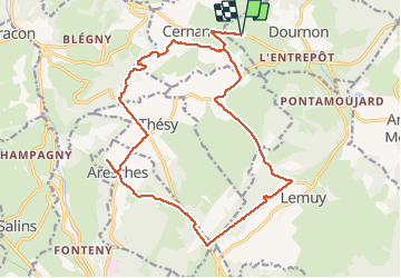

Length
20 km

Max alt
706 m

Uphill gradient
348 m
Km-Effort
25 km

Min alt
607 m

Downhill gradient
347 m
Boucle
Yes
Creation date :
2020-09-10 06:56:28.208
Updated on :
2020-09-10 13:26:19.544
4h51
Difficulty : Very easy

FREE GPS app for hiking
 SityTrail
IGN / Geographical institutes
SityTrail Plus
The world is yours!
About
Trail Walking of 20 km to be discovered at Bourgogne-Franche-Comté, Jura, Dournon. This trail is proposed by cmike39.
Photos

Positioning
Country:
France
Region :
Bourgogne-Franche-Comté
Department/Province :
Jura
Municipality :
Dournon
Location:
Unknown
Start:(Dec)
Start:(UTM)
724458 ; 5201756 (31T) N.
Comments