


locquiniol

Michel Zante
User

Length
11.4 km

Max alt
171 m

Uphill gradient
107 m
Km-Effort
12.8 km

Min alt
136 m

Downhill gradient
107 m
Boucle
Yes
Creation date :
2020-09-10 12:04:50.981
Updated on :
2020-09-10 20:45:54.103
2h14
Difficulty : Very easy

FREE GPS app for hiking
 SityTrail
IGN / Geographical institutes
SityTrail Plus
The world is yours!
About
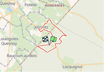
Trail Walking of 11.4 km to be discovered at Hauts-de-France, Nord, Locquignol. This trail is proposed by Michel Zante.
Positioning
Country:
France
Region :
Hauts-de-France
Department/Province :
Nord
Municipality :
Locquignol
Location:
Unknown
Start:(Dec)
Start:(UTM)
549214 ; 5562765 (31U) N.
Comments