


Caves

crognon
User

Length
16.3 km

Max alt
235 m

Uphill gradient
319 m
Km-Effort
21 km

Min alt
29 m

Downhill gradient
319 m
Boucle
Yes
Creation date :
2020-09-11 07:30:59.444
Updated on :
2020-09-11 14:04:13.895
6h32
Difficulty : Medium

FREE GPS app for hiking
 SityTrail
IGN / Geographical institutes
SityTrail Plus
The world is yours!
About
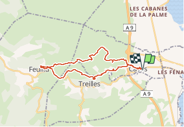
Trail Walking of 16.3 km to be discovered at Occitania, Aude, Caves. This trail is proposed by crognon.
Positioning
Country:
France
Region :
Occitania
Department/Province :
Aude
Municipality :
Caves
Location:
Unknown
Start:(Dec)
Start:(UTM)
498290 ; 4753116 (31T) N.
Comments