


Valdahon

tiene
User
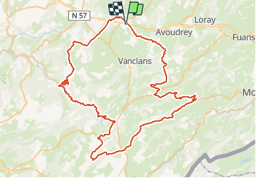

Length
92 km

Max alt
1062 m

Uphill gradient
1680 m
Km-Effort
115 km

Min alt
345 m

Downhill gradient
1681 m
Boucle
Yes
Creation date :
2020-09-11 07:38:07.098
Updated on :
2020-09-11 19:44:53.75
5h14
Difficulty : Difficult

FREE GPS app for hiking
 SityTrail
IGN / Geographical institutes
SityTrail Plus
The world is yours!
About
Trail Road bike of 92 km to be discovered at Bourgogne-Franche-Comté, Doubs, Valdahon. This trail is proposed by tiene.
Positioning
Country:
France
Region :
Bourgogne-Franche-Comté
Department/Province :
Doubs
Municipality :
Valdahon
Location:
Unknown
Start:(Dec)
Start:(UTM)
298561 ; 5224837 (32T) N.
Comments