


AIRE DE LA VENTOUSE - PUY DE COMBEGRASSE

walrou63
User
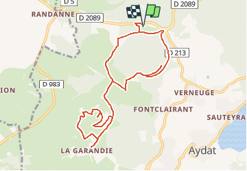

Length
10.8 km

Max alt
1114 m

Uphill gradient
263 m
Km-Effort
14.3 km

Min alt
952 m

Downhill gradient
264 m
Boucle
Yes
Creation date :
2020-09-11 15:48:44.719
Updated on :
2020-12-06 09:44:33.138
3h02
Difficulty : Difficult

FREE GPS app for hiking
 SityTrail
IGN / Geographical institutes
SityTrail Plus
The world is yours!
About
Trail Walking of 10.8 km to be discovered at Auvergne-Rhône-Alpes, Puy-de-Dôme, Aydat. This trail is proposed by walrou63.
Positioning
Country:
France
Region :
Auvergne-Rhône-Alpes
Department/Province :
Puy-de-Dôme
Municipality :
Aydat
Location:
Unknown
Start:(Dec)
Start:(UTM)
496954 ; 5058806 (31T) N.
Comments